Sierra 2000 O-Fest
Spooner Lake "Warmup" B-Meet
Saturday, July 29
Contact: Evan Custer, course setter and co-meet director
The Spooner Lake "Warmup" B-meet will take place at the Lake Tahoe-Nevada State Park at Spooner Lake. The park is located on the east side of Lake Tahoe, in Nevada, on Nevada Route 28 about 1 kilometer north of the U.S. 50-Route 28 intersection. The nearest towns are Incline Village, NV, about 15 miles north; South Lake Tahoe, California, about 15 miles south; and Carson City, Nevada, about 22 miles east.
The terrain is predominantly open, runnable Ponderosa pine forest, is moderately steep, has a very sparse trail network, and contains multiple rock features. The ground is quite sandy in most areas, and provides very soft running. The visibility generally is excellent. There are no rattlesnakes or poison oak. The elevation is 7000 feet, which may cause you to feel slightly short of breath on even relatively mild climbs, unless you are accustomed to higher altitudes.
Courses
All standard 7 courses (white, yellow, orange, brown, green, red, and blue) will be offered. There will also be free beginner's clinics and a Start-O course for young children.This event is open to newcomers - come out and try a white, yellow, or orange course! You can get more first-timer details on our Recreational Courses page.
Here are the course statistics:
	White	2.7 km long	20 m climb	9 controls
	Yellow	3.025 km long	90 m climb	9 controls
	Orange	3.4 km long	125 m climb	10 controls
	Brown	3.2 km long	135 m climb	11 controls
	Green	4.0 km long	245 m climb	9 controls
	Red	5.375 km long	385 m climb	11 controls
	Blue	7.325 km long	420 m climb	16 controls
Map
This is the second use of this map. It was used in September 1999 for the U.S. Individual Classic Distance Championships. It was field-checked and drafted by George Kirkov in 1997. Corrections were made last summer by George Kirkov and Bob Cooley. It was drawn to IOF specifications on OCAD 7, and will be printed at 1:10000, 5 meter contours, by an Epson Stylus Ink Jet printer.Electronic Punching
This will be the first major orienteering event in the U.S. to use electronic punching. SportIdent electronic punching will be used on all courses at this event, including white and yellow. You must have a SportIdent e-card in order to participate. If you do not own your own card, you may rent one for $2. If you have never used SportIdent electronic punching, there will be a demonstration unit available at the registration area.At the start, you will first clear your e-card at the clear station. Then after you enter the pre-start area, you will check your e-card at the check station. At the start line when you are told to start, you must punch the start control. This will be your start time and your elapsed time will be calculated from this. Therefore, for this event (as opposed to the three A-meets later in the week), it is not crucial that you start exactly at the sound of the timer. You do not have to rush to punch your e-card right at the timer, as the time calculation does not begin until you actually punch.
At each control, there will be an electronic control unit. You will insert your e-card into the control unit, and wait until it beeps and the light flashes (less than 1 second). You must wait until it beeps and flashes, or your punch will not be correctly recorded, and you may be disqualified. If the control unit fails to beep and flash (highly unlikely), then use the standard needle punch at the control to punch one of the reserve boxes printed on the map (R1, R2, or R3).
At the finish, you must punch the control unit. This will record your finish time. Then stay in the finish chute until you reach the download station. Insert your e-card into the unit, and wait for it to flash and beep. Then the data from your e-card will have been transferred the computer. Results will be posted periodically.
Registration and Start Times
Pre-registration is not required; you can show up and sign up on-site the day of the event. However, if you are attending the Sierra 2000, you may want to pre-register by filling out a Sierra 2000 O-Fest entry form and mailing it with your check to the registrar. (Mail entries close July 17.)If you have pre-registered for the O-Fest, you may pick up your packet at the registration area. If you are registering on-site, go to the registration area, fill out the forms, and pay your entry fee.
Registration opens at 10:00 a.m., and the first starts will be at 11:00 a.m.
Fees
For the white and yellow courses, the entry fee $6 for an adult or the first person in a group, and $3 for juniors (age 20 or younger). Each additional person in a group is $2 (juniors, $1).For the orange and advanced courses, the fee is $8/adults and $4/juniors for any member of a USOF-chartered orienteering club. Non-club-member fees are $12 adults and $6 juniors. Additional group members are $2 each (juniors, $1).
SportIdent e-card rental is $2. Compass rental is $1. Start-O is free.
Start
There are two start areas. Start 1 is a remote start ( about 1250 meters distance and 50 meters climb) for the green, red, and blue courses. Start 2 is for the white, yellow, orange, and brown courses and is very close to the registration area.People who have pre-registered will be assigned start times. However, since this is a B-meet, we will allow day-of-entry registration. After registering and renting an e-card (if necessary), you will go to the start area and request a start time. Vacant slots will be placed in the start schedule to accommodate day-of-entry participants.
You should clear your e-card at the clear station prior to being called up at the start line. At about 4 minutes before your assigned start time, you will be called up and check your e-card at the check station. At 2 minutes before your start, you will advance to the start line. At your start time, you will punch your e-card at the start station and follow the streamered route to a remote start triangle where you will pick up your map and begin navigating.
Warm-up Area
You may warm up on the road leading to the remote start. The start area is a short distance from the road.Amenities
Flush toilets are in the park bathrooms, about 250 meters from the registration area. Water will be provided at the start and finish, and at designated controls on the courses.Hazards
The biggest hazard at this event is probably the altitude. You will be competing at 7000 feet. One of the best ways to decrease some of the effects of high altitude is to stay hydrated throughout the competition. Start drinking water about 1 hour before your start, and drink water at all of the water stops. If it is warm, it is even more important to stay hydrated.Some of the terrain is quite steep. Take caution when going down steep hillsides. There is no poison oak or poisonous snakes. A bear was sighted last year by one of the course designers. However, Tahoe bears are generally non-aggressive.
The safety bearing is south or west, until you come to Highway 50 on the south, route 28 on the west, or the west side of Spooner Lake.
Whistles
Whistles must be carried by all competitors. If you do not have a whistle, ask for one at registration.Start-O
Start-O is a form of score-O for young children. They will receive a large-scale map (1:600) of a small area near the event center. There will be a number of controls marked on the map. In the field are mini-controls with punches. Each child receives a punch card. The child finds the control using the map and punches the card. However, there are no codes on the controls or card, so that they have to figure out from the map and feature which box to punch.The course can be done by one child alone, or as a small group of 2 or 3, with or without adult help. The score-O is free.
Parking at the Event
The rangers have agreed to let orienteers park on designated access and service roads within the park. You will enter the park from Route 28, about 1 kilometer north of the intersection with US 50, pay a $5 per car parking fee at the kiosk, and follow the parking signs and directions of the parking crew. The access road on which you will park will be one way, and you will exit the park at a gate south of the main entrance. Please do not park in the regular paved parking areas, as these spaces are reserved for other park users.Directions
For a logistical overview of the venue, look at this map.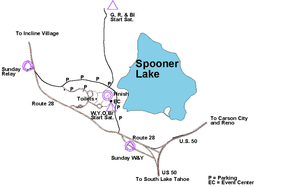
From Northstar and North Lake Tahoe: Take Route 267 south towards Kings Beach. At the T-intersection, turn left onto route 28 east. Go for another 18 miles until you see O signs.
From Reno: Take U.S. 50 west through Carson City and up Spooner Summit. After crossing the summit, turn right onto Route 28 north towards Incline Village. Follow O signs to parking.
From the Bay Area: Take I-80 east towards Sacramento, then US 50 east towards South Lake Tahoe. Continue on US 50 through South Lake Tahoe, and about 14 miles later, turn left onto Route 28 North.