

Harvey Bear Scenes
(click on images for larger copies)
Coyote Lake–Harvey Bear Ranch County Park
Date: (Sun.) Feb. 6, 2022
Location: San Martin, CA
Event Director: ![]() - 650.906.9672
- 650.906.9672
Course Setter: Lubomir Sebo
Type: B; Standard 7-course event for beginners through advanced; at different parking lot than for previous events
Related Event Information
Event Announcement Online Registration (https://eventreg.orienteeringusa.org/eventregister/a40/register/start/harveybear)
Course Setter’s Notes
By Lubo Å ebo
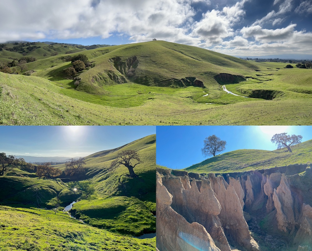
It has been two years since our last event at Coyote Lake–Harvey Bear Ranch County Park. The park has been refreshed by the abundant rain, and is ready for the beginning of our 2022 orienteering season.
This time we will meet in the lower part of the park, and enjoy a little-used section of the map. Follow our directional signs to parking and the Assembly Area off E San Martin Ave (GPS 37.0992,-121.5739; directions are here). There is no park fee collected at this entrance. There are restrooms available at the Assembly Area. This park is dog friendly (on leash) and horse friendly.
Plan to arrive before 11:30 AM, because registration will close then. There is a long walk to the single Start location for all the courses. The walk to the Start is 1.4 mi (2.25 km) with a 100 m climb. Plan at least 30 minutes to get there. There are no restrooms at the Start location. Since you will pass the Start on your way back from the Finish, you can leave clothes at the Start if you want (but please don't forget to pick them up).
There is no drinking water at the control locations (no water controls)—you are encouraged to bring water to the event, and take it on your course. There might be a limited amount of bottled water available at the Start/Finish areas.
The Finish is located 300 m from the Start and 1.6 mi (2.5 km) from the Assembly Area/Parking. Please visit the Download tent at the Assembly Area before leaving, even if you did not complete the course. It is important for us to know that everyone made it back.
There is almost a complete lack of thick vegetation, so gaiters are optional. Hillsides are generally less steep than in most of our venues, although the sides of many erosion gullies are very steep. The ground is muddy in a few places; if we have more rain before or during the event, those places could be very muddy.
Course Details
Course Length Climb Controls Navigation Map Scale
    White    3.6 km    70 m  1.9%    11     Beginner        1:7,500
    Yellow   4.0 km   110 m  2.8%    13     Adv. Beginner   1:7,500
    Orange   4.6 km   200 m  4.3%    12     Intermediate    1:7,500
    Brown    4.2 km   120 m  2.9%    10     Advanced        1:7,500
    Green    5.4 km   230 m  4.3%    12     Advanced        1:10,000
    Red      6.9 km   250 m  3.6%    16     Advanced        1:10,000
    Blue     8.1 km   340 m  4.2%    22     Advanced        1:10,000
Map
The magnetic North lines on the maps are at approximately a 45-degree angle for a better fit of the course area on the legal-size paper.
The distinction between individual trees and forest is still a little vague. Sometimes what appears to be an individual tree close to a forest might be mapped as part of the forest. A brown × denotes a fallen tree, while a green × represents a standing dead tree.
There are many unmapped animal trails, and increasingly more unmapped fallen trees.
Hazards and Wildlife
Poison Oak is easily avoidable in this part of the park. Its leaves are just about to appear.
The usually present wild pigs have not been spotted this year.
There are many cows with their young ones. Try to not startle the cows—run around groups of cows rather than through them. Never get between a calf and its mother!
Horses
This park is popular with equestrians. Don’t startle horses—give them the right of way (ask the rider if it’s okay to run around). Never run by horses. They can be startled and bolt, putting the rider at risk. The best etiquette upon approaching a horse and rider is to slow to a walk, and say “hello†to the rider. This will let the horse know that the object approaching them is a human. (Apparently, horses do not have sharp eyesight.)
Course Comments
Hydrate well before going to Start, and take water with you. There are no water controls on any of the courses.
Some controls for different courses are close to each other, so don’t forget to check the numbers. "H" in a control description indicates that the control is hanging on a tree.
White Course (Easy Beginner)
The White course follows trails. You will need to recognize them on your map and in the terrain, and make the correct turns at the trail junctions. It is fine to take “shortcutsâ€. The White maps should be available at the Registration table at the Assembly Area.
Yellow Course (Advanced Beginner)
The Yellow course encourages simple off-trail navigation. You will mostly follow trails, and will need to leave the trail near the controls. There is a generous climb in the middle of the Yellow course. It is fine to come back to the nearest trail if the off-trail navigation becomes challenging.
Orange Course (Intermediate)
The Orange course is off-trail and focuses on contour reading. Save your energy, since there is a lot of climb in the middle of the course. There is no need to cross barbed-wire fences on the Orange course—use the gates on the trails.
Brown, Green, Red, and Blue Courses (Advanced)
The advanced courses are designed for orienteers who are able to make full use of their maps, compasses, and the terrain. Depending on the route choices, it is possible to avoid fence crossing, although that might not be optimal. Don’t jump or climb over fences. Roll under the wire—it is quick and safe, and won't damage the fence.